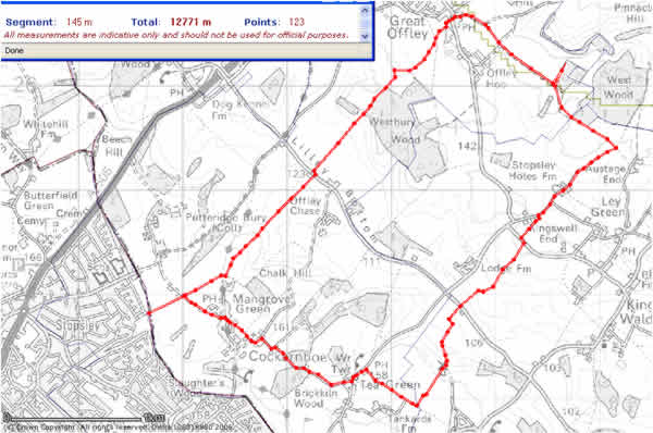
Luton East FOOTPATH 9
A cycle 'yomp' exiting Luton east on footpath 9, via Mangrove, Cockernhoe,
Tea Green and Offley in the late August, north Hertfordshire countryside.
12.7 Kilometres, about 8 miles. Boots if walking! Hard going but do-able on bike.


I cycled 3 miles from the centre of Luton to the boundary here. This green
space is on the East of Luton in Stopsley, as a youngster I grew up in Stopsley
and we used to know this green space as 'The Glen' The exit 'footpath 9' is
straight ahead.

A close up view of the start of the footpath

One could of course, park ones car here (providing of course - you respect the
local neighbourhood) From Stopsley village roundabout take Putteridge road,
drive about 1 mile till you get to Selsy Drive (last turn right before you enter
the
private Putteridgebury estate) Drive to end, park up enter 'the Glen' ahead
and
turn left.

Oops! only got my shorts and a vest. The first test! Get past those nettles
without
getting stung! Stinging nettles are a hazzard in the summertime Mud another
hazzard other times of the year. At least it was dry today. The Romans with
their
bare legs used to love thrashing themselves in stinging nettles, not I though!

Followed the southern wall of the Putteridgebury estate east. After 400 metres
came upon a gate with a track crossing my footpath from the north. This pick
is
looking over the gate in a north direction towards the centre of the Putteridgebury
estate

From the same place as the previous 'over the gate' shot, but looking south
towards Mangrove

From the same spot as the previous 2 shots. This time facing east. Our ' footpath
9'
continues ahead continuing along the southern boundary of the estate. That's
Mangrove manor in the background We are not going that way though, we are
heading south.

We have turned right and are heading south on a footpath towards the village
of Mangrove.

Getting closer to Mangrove now Strange cream coloured building ahead.

From the same spot as the previous shot, this time looking southwest
towards Cockernhoe and beyond that, Luton Airport. Spot the hot air
ballon to the right of the crane, getting dangerously close to the runnway;
it put down shortly after this shot!

After crossing the road on Mangrove village green (sorry didn't get a shot
-Doh!) followed a footpath leading south east towards Cockernhoe. It
opened into a cluster of meadows. Here we look back towards Mangrove
village.

From the same spot but looking at the footpath ahead. Tricky on a pushbike
with a couple of styles to conquer. Alternatively a cyclist could have used
the
road we just crossed and cycled through the village and turned left at the road
junction at Cockernhoe to reach the point where the footpath rejoins the road.
But we are on a cycle 'yomp' after all !

Passed over a Style into the next meadow. This shot looks south west toward
the village, again you can make out Luton Airport in the background. The two
horses look be-mused by my presence

An example of one of the many Style's on this stretch

The footpath leaves the meadows here at Cockernhoe Green. This shot is
looking southwest down the wide green, a road is seen winding it's way towards
the left. This is the road mentioned earlier that could be used to avoid the
meadows
and Styles. After one mile of leaving Luton we have now entered the old world
of quaint rural hertfordshire. This whole area is under threat from the planned
developement of Luton Airport.

Cockernoe Village Church Front :photo taken looking east. The villages of
Mangrove and Cockernhoe are co joined, they share this strange church.
Unlike nearly every other village in the area that often have majestically built
focal points, this one is constructed from corrugated iron and is little more
than
a prefabricated hut! I wonder what the story is here?

Cockernoe Village Church Side :photo taken looking north Taken from the
road I have just turned left onto

From a point a few metres from the previous pic, on the southern green.
The village pond is in the middle, with the entrance to Cockernhoe farm
beyond the parked car. Beyond that in the distance, the road we are now
following, heading east, reaches a right turn. The road going straight on leads
to Chalk Hill and beyond that, Lilley Bottom. We are going to take the right
turn towards Tea Green (by the horse rider in the distance)

Brick Kiln Wood Along the road from Cockernhoe to Tea Green there is a
copse or 'spring' as they are sometimes called round here! Many of these on
this Chalk/Clay platteau hide countryside sectrets! This 'Wood', 'Copse' or
'Spring' is on the site of an old clay pit. The local clay's were used by the
brickbuilding industry's in the past in these flat topped hills. Each village
would
have it's own brickworks with a handfull of workers hand baking bricks.
The colours and texture's produced bearing an unique quallity to bricks
produced to the various areas ie. 'Stopsley reds' etc etc The brickbuilding
industry has long vanished in this area but it's traces can be found all over.
Seen here looking down into a clay pit now covered over by trees.

Beyond Brick Kiln Wood A little further, on up the road from Cockernhoe
to Tea Green, these two semi-detached cottages, undoubtedly built out of the
local bricks, adopt an architectural style that utilised the locally produced
bricks
to produce a character prevalent in this part of the northern Chilterns. Above
the brown front door can be seen a plaque. The symbol in the plaque is that
of a white lion standing on it's hind legs. This symbol can be found over a
wide
area round here, notably the village of Lilley has scores of these symbols on
various cottages.

It is about three quarters of a mile from Cockernhoe to Tea Green.
To the south of the two cottages on the south of Brick kiln wood are to be
found these strange tents! Is it some kind of strange summer camp for errant
campers? or maybe some kind off greenhouse complex, or perhaps some sort
of animal prison camp? We are still on the road here, there are footpaths nearby
but we are following a topographical high route following roughly the highest
ground southeast. The network of old lanes, footpaths and minor roads, trace
or echo hints of an earlier ridge way. The ground falls gently down from each
side of the road ahead a sure sign of the old 'high-way'

Further along the road from Cockernhoe to Tea Green, Although this 'ridge way'
traces the highest ground on the soft rolling hillsides, ponds and puddles are
common! The clay capped tops of these hills prevent the escape of water.
In the background can be seen some cottages on the edge of Tea Green.

Tea Green at last! The distinguishing features of the white water tower can
be
seen above the public house in the background.

Tea Green; Beware of low flying planes !

Tea Green Accross the green a row of white clad, brick built farmers cottages

Tea Green: Ahh that white lion again! Look at the luxuriosly textured brickwork
on that house! The owner of this property certainly has a fine example of local
brickwork. The White Lion symbol is a clue to the past ownership of vast swathes
of land in this district. The land owner was the Putteridgebury estate who's
symbol
was, yes you guessed it! a white lion standing on it's rear legs!

The White Horse, Tea Green The public house and water tower are the focal points
for the village. The pub perfect for refreshment

Stony Lane, Tea Green Hmm thats an idea! I wonder what lies in that name?

At reaching Tea Green we head left down 'stony lane', past the White Horse and
take a footpath right (south) by the water tower. Pictured looking east down
stoney lane, but we are trning right here! There is a public footpath sign directing
us to 'the heath'

Before we take the footpath, looking back this shot is featuring the rear of
the
White Horse public house. What caught my eye was that tall chimney stack!
Quite an odd feature

The footpath still keeping to the high ground heads toward 'the heath' 'The
Heath'
mentioned is an area of the village of Breechwood Green, which for us as kids
searching for countryside mysteries was an area of fascinating discoveries to
be had;
indeed, one summer me and my mates found an abandoned windmill somewhere
along this footpath and had hours of fun clambering about it's remains.
This shot is a typical landscape view looking north east from the footpath.

The footpath continuing toward Breechwwod green and 'The Heath' Following
the top of the ridge.

Another view this time looking northeast towards Offley

Looking southwest from same path. More low flying planes!

About a querter of mile from 'The Heath' we take a footpath left accross
freshly harvested fields of wheat. In the distance is some sort of black tower!

The path now leaving the old ridge way and heading downhill east towards the
dry upper mimram valley. The path follows an old hedgeline now cut away leaving
the odd tree to trace its line. The farmer has pressed out a narrow strip of
unharvested wheat to mark the footpath.

That tower thing, is that the old windmill?

Breechwood Green Windmill Wow it's been done up as a home! But painted black!!

From the same spot as the previous photo, this time looking south towards 'The
Heath'

Breechwood Green Windmill! This was the scene of one of our secret treasures,
as kids
myself and a couple of our mates had bycycles and would adventure a little further
than
most from our 'village' of Stopsley and would hasten back to boast of our exploits
to the
others. On one summer holliday we found this old abandoned windmill overlooking
a valley
and for the rest of that summer spent wonderfull hours of bliss in our very
own
adventure playground.

Heading east down the cut footpath. This was interesting on my bycycle! Scrunching
wheat stems, I wondered about the abillity of these to puncture my tires

More windmill As far as I can remmember, there wasn't much left, if anything
of the
great sails, even back then in the late 60's But we could get right up into
the 'haunted'
upper areas of the building. Our mothers would have been horrified!

A close up of the top of the Breechwood Green windmill.

The footpath passes 100 metres to the north of the windmill and passes a deep
lyncheted hedgerow onto a hillside overlooking the dry upper Mimram valley.
Here looking southeast on a fine August day.

A close up of the base of the Breechwood Green windmill; now a private home.

After entering thefield behind the windmill the footpath heads straight on a
little over
50 metres or so then heads left in a northeast direction,.following the right
side
of the hedgerow.

Breifly rising slightly uphill, past the 'fireweed' on the left, the footpath
curses a vague
track bending from north east to east.

Shot taken from same spot as previous point but looking souteast towards Kings
Walden
. Bute-eee-full this countryside; could almost eat it for breakfast!!

Windmill cottage can be seen ahead at the valley floor. Our footpath winds it's
way along
the hedgerows toward the cottage, then up the opposite side of the valley after
first
crossing the Lilley Bottom road

Toward 'Windmill cottage' a hedgerow view looking south

Windmill cottage again we will be following that hedgerow leading up the hill
towards
Ley Green in a couple of minutes!

Looking south east towards Kings Walden.
You can just make out the church tower (upper middle top of photo)

Looking back at the Breechwood Green Windmill. It is clear that this windmill
held
a dominant position in the landscape in this part of the Mimram valley.

Now we have crossed the Lilley Bottom to Whitwell road by the 'windmill cottage'
we are on a signposted footpath that is heading up the hillside on the other
side of
the valley. This photo is looking back towards the west side of the valley.
Chalk Hill is on the right.

Another view looking west of Chalk Hill

Footpath to Ley Green, looking south west toward Bendish, on the hill in the
distance.

Footpath to Ley Green, a slow ride up the hill. A slight incline but heavy going!

Oh dear, this 'cycle yomping' is going to get tougher! The path ahead has been
ploughed!

Another shot looking back south east from the same point toward Bendish,
as we contiplate the ploughed field.

Footpath to Ley Green, Here goes....... not too bad actually but the ground
is dry at
the moment. would hate to traverse this when the ground is wet!

Footpath to Ley Green, And another ploughed field!

Footpath to Ley Green, Think that may be it! Am now at the top of this deceptively
high but long elavating hillside. It has been quite a struggle and we are now
entering
the 'golden hour' (the hour before sunset) whereby the colours really begin
to radiate a
rich golden glow.
That hedgerow is the road heading south to Ley Green.

Road to Ley Green, Looking north, we have just turned left onto this minor lane
which
reminds one of the old 'hollow ways' We enter this road from the footpath, turn
left
(heading north) and after a few metres only, take a footpath to the right!
You can just see the sign to the right!

Road to Ley Green, Looking south, we have just turned left onto this minor lane
which
reminds one of the old 'hollow ways' 'Ley' means clearing in the woods, these
hills were
previously to human inhabitation, forested. When the Saxon's started to clear
areas of the
forest, the villages would be named after the original guy who cleared an area
of forest.
For instance Stopsley was named after a guy called 'Stoppes' who cleared an
area of the
woods and set up home. After time this developed into a community with a cluster
of
homes, hence 'Stoppes' clearing - 'stopess-ley' to the modern day 'Stopsley'
Ironically
'Green' can also mean clearing! Hence 'Ley Green' could mean 'Clearing in the
Clearing'!
Similar to the old river Avon in old British (Welsh) 'Afon'
-hence saying the River Avon, is like saying 'the River River' !

One last view west before we take the footpath east

We now enter a wooded footpath/ bridleway east, heading towards 'Stopsley Holes'
farm.

Continuing along a wooded footpath/ bridleway east, heading towards 'Stopsley
Holes' farm.

Now exiting the wooded footpath/ bridleway east, heading towards 'Stopsley Holes'
farm.
We now follow a narrow minor lane

Stopsley Holes Farm. Hmmm, in a slight dip in the gently rolling countryside,
could never
work out why this area should be named after a village, 4 miles east in the
neighbouring
county of Bedfordhire?

At Stopsley Holes, the track follows another 'Hollow way' up through those trees!
(looking east)

Really the 'Golden Hour' now! Loved the patterns of warm orangy colours here
An old stump of a small tree or shrub glows with the last golden rays of the
day.

Another old stump of a small tree or shrub glows with the last golden rays of
the day.

Here comes the writer still heading east but thinking about heading back soon
as it is sunset!

The writer having a fling on his bike!

Sunsets! Probablly the singlemost popular item of digital photography,
this show's I am no different!

Austage End We now decide to head to Offley so we turn left on a Bridleway
short of 'West Wood'

Cycleway 16 Hmm .. It seems we are on an official cycleway!

Onward North - northwest toward Offley

Hey this old track resembles tha classic characteristics of a 'ridge way'

Looking east towards 'Pinnacle Hill' (unseen here) from the same point as the
previous pic.

Still can't see 'Pinnacle Hill' think its below to the right! But this is as
far as I dare go today,
this shot has a tantilising view of the northeast of the Offley scarp. But it
is seriously getting
dark now, with the return journey in mind, it's time to head back!

Another one of those sunset shots!

The 'Red Lion' public house. Offley We have had the 'White Lion', 'White Horse'
and
now the 'Red Lion'. Could only dream of getting refreshed here, but with the
onslaught
of dusk and many 'unchartered' (by me) footpaths to traverse, I had to cut back
to Luton.

Chicken Sheds in Offley. After leaving the bridleway, thats exits to the left
of the Red Lion
(Harris Lane), look for the 'Icknield Path' signost, pointing west on the opposite
side of
Kings Walden Road. Lift your bike over the gate and follow the concrete track
round
to the left, then straight on. You pass these chicken sheds.

Following the concrete path beyond the chicken sheds in Offley Looking west

Yawn!

It is now getting too dark for my camera, we are following a rough track now.
We are in the area that the legendary saxon King that united the English and
built the
huge Dyke that seperates England and Wales that is named after him. King Offa.
After fighting a terrific battle along these hills with his adversary and winning,
he went on to build his Palace in this locality, although it has never been
found.
From here he moved to build Hitchin Priory and then St. Albans Abbey.

No more photo's,, much too dark now but I continue following this track right
the way
back down and accross the dry upper Mimram valley, perhaps 1 mile north to the
trail
I followed out here, eventually linking back up at Mangrove Manor on the south
side
of the Putteridgebury estate with the 'footpath 9' at the gate where I had originally
diverged south earlier. On the way, a great beast, suprised by my 'stealthy'
interuption,
bounded it's way accross the field ahead. The hairs on the back of my neck stood
on
end as memories of another dusk 'yomp' and the sighting of giant big cat came
too mind...but that's another story... I didn't hang about!